Since many of us in the Northern Hemisphere are currently shivering through a cold, dreary winter, I thought it might be nice to take you on a virtual walk through the colorful Cinque Terre — that string of five charming villages along the north Italian coast.
My husband Brent and I spent a month there last fall, and thankfully, I took a few thousand photos that will help guide us along the way.
We stayed in the town of Levanto and found it the perfect home base for this area — something we wrote about in our Cinque Terre tips.
Levanto is located just to the north of Cinque Terre National Park. It’s not quite as photogenic as the villages in the park, but I found plenty to admire.
Never Miss a Beat
Subscribe to our newsletter to stay ahead of the latest LGBTQ+ political news and insights.

And Levanto is also the start of a series of famous trails that connect all of the Cinque Terre. This first part is a fantastic hike, with great views of the Ligurian Sea and Monteresso al Mare, the first of the five villages.
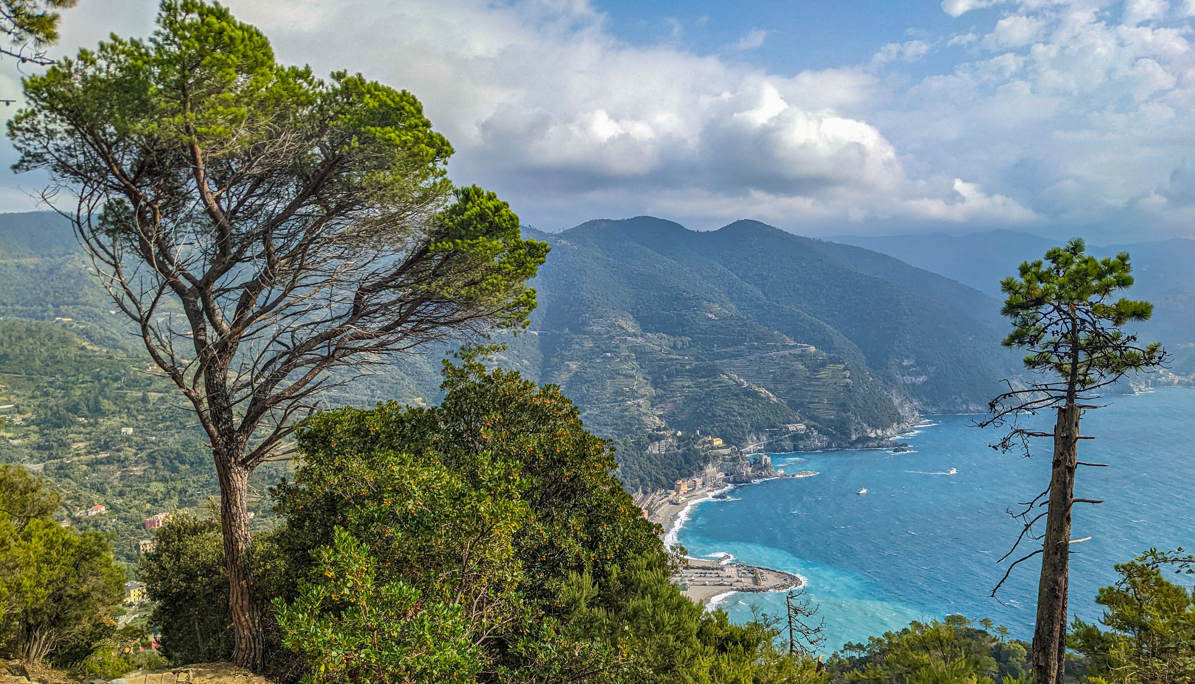
Monterosso al Mare
Monterosso — “al Mare” means “by the sea” — is the largest village in the Cinque Terre. But I think it’s the least charming. I suspect it’s so popular because it has the most amenities.
The relative lack of charm may have to do with geography. The other villages are tucked up into sheer valleys or built high up on dramatic bluffs.
But Monterosso does have the Cinque Terre’s best beaches. It’s also known for Convent of the Capuchin Friars, nicely situated on a massive seaside rock in the middle of town. As you can see from the picture below, the friars had a pretty decent view.

Monterosso is also home to Il Gigante, a partially ruined sculpture of Neptune, just above one of the beaches.
Built in 1910, this 14-meter tall concrete colossus was damaged in World War II by Allied bombs, then clobbered by storms in 1966. Today, it stands a lonely watch over the blue sea forever lapping at its feet.

Vernazza
As you head south from Monterosso, you’ll soon reach Vernazza. You can go by boat or train — or even by car, though very few do. But for the purposes of this article, we’re still hiking on what is now called the Blue Trail — the name of the trail between the five villages.
(Don’t expect all four of the “official” legs of the trail to be open. Farther down the coast, the famous Via dell’Amore, or the Path of Love, has been closed since 2012 due to a mudslide, and repairs are going very slowly. This is Italy, after all. But walking between the villages is very popular, so there will always be some kind of hiking workaround.)
Brent and I were on the Blue Trail from Monterosso, and I still recall how amazed I was when I got my first look at Vernazza’s stunning harbor.

I also loved the famous colored buildings of the Cinque Terre standing watch over the little harbor.

I returned to Vernazza again and again, but my favorite time was at sunrise. I always had the whole town to myself!

Corniglia
Setting off on the trail for Corniglia, you’re now deep in Cinque Terre National Park, and the incredible views just keep coming.

They’ve been growing and harvesting grapes and olives in these hills for centuries. The work is still hard, but it got a bit easier in the 20th century when farmers installed these simple tracks that hauled the harvest up and down the steep, terraced hillsides.

On the rocky trail, Corniglia soon appears in the distance. It’s very unlike the other villages in the Cinque Terre, as it’s located on a promontory above the sea — 100 meters above, to be exact.

This location makes Corniglia the only village of the Cinque Terre not reachable by ferry. The train does stop here, but the station is located down along the water, so you’ll have to walk the 382 steps up the famous Scalinata Lardarina — the Lardarina Staircase.

Manarola
Along with the Via dell’Amore, the leg of the Blue Trail between Corniglia to Manarola is currently closed, which means you have to hike the long way around.
And it’s a bit challenging. It starts with 1200 steps going almost straight up.

But once you reach the top, you’ll be glad you made an effort. Not only do you get yet more spectacular views of the Ligurian coast, you’ll also get to hike directly through some of the Cinque Terre’s famous vineyards and olive groves.
Alas, Brent and I just missed the grape harvest, which would undoubtedly have made for some fantastic photos. But just as with many trees, grape leaves turn lovely shades of gold and red come fall.

Manarola wasn’t founded until the 13th century. Before that, people lived in these hills, possibly as far back as Roman times.
But eventually, you reach the village itself.

Monterosso may have the best beaches, but Manarola has another spectacular harbor, this one deep, with plenty of rocks to jump off. This has made it the Cinque Terre’s unofficial “swimming hole,” and it’s a great place to cool off on hot summer days.
Even in late October, when Brent and I first visited, there were plenty of swimmers taking advantage of the water’s lingering warmth.

If I liked Vernazza in the morning, I preferred Monterosso at sunset. Alas, so did fifty zillion other people, which made getting good pictures difficult.

Riomaggiore
I said earlier that the Via dell’Amore is closed until 2024 — that’s the leg of the Blue Trail between Manarola and the final village, Riomaggiore. It runs along the ocean side of the rocky hill between the two villages.
There’s currently a workaround, but it means going straight up one side of that hill, then straight down the other side. The grade on each side reaches 47%!
Despite being on that hill, it’s also the least scenic of all the hikes so far.

But this is also the shortest hike, less than two kilometers, and it’s all worth it when you reach Riomaggiore.

Riomaggiore is famous for the way it’s nestled inside a very steep ravine. Along the sides, the buildings rise up very dramatically.

The main thoroughfare is Via Colombo, and it, of course, is packed with restaurants, cafes, and bars.
More importantly, I found all kinds of photographic surprises, including a “gay” bench the city installed to show its support for the LGBTQ community.

Portovenere
In our travel tips for the Cinque Terre, Brent mentioned a bonus “sixth” village called Portovenere that isn’t on the train line. Since it’s a bit harder to reach — and since it’s not “officially” part of the Cinque Terre — it is sometimes overlooked.
The hike out there — which is long, over twelve kilometers — is rugged and difficult, but it was probably our favorite. There are ancient churches and villages you hike past, and more vineyards and olive groves.
And, oh man, those views.

As for Portovenere, I loved that too, especially from a photographer’s perspective. It seemed to have everything, from one of the prettiest waterfronts I’ve seen in Italy…

…to the 12th century Church of San Pietro watching over the ocean…

…to the Platonic ideal of an Italian street.

Portovenere was also home to the best deep-fried calamari Brent and I have ever tasted — light and crunchy, with a hint of salt and a squirt of lemon.

We’ve finally reached the end of our pictorial hike through the Cinque Terre. Whatever the weather, wherever you are in the world, I hope it brightened your day!
P.S. Here’s the whole journey:

Michael Jensen is an author, editor, and one half of Brent and Michael Are Going Places, a couple of traveling gay digital nomads. Subscribe to their free travel newsletter here.
Don't forget to share: